


The Arctic Silk Road: A Quiet Battle for the Future
A ship going from Shanghai to Rotterdam takes 20 days via the NSR, versus 35 through Suez. That’s a 40% time savings, and it’s why everyone’s paying attention.
The Arctic feels like a place where time slows down—endless ice, a sun that barely moves, and a silence that stretches for miles. But beneath this stillness, a competition is brewing, one that could shape the world’s economy and power dynamics for decades. The Arctic Silk Road, a network of shipping routes through the melting polar ice, isn’t just a new path for trade—it’s a window into how nations think about risk, reward, and the long game. By March 18, 2025, the U.S., Russia, China, and NATO allies like Canada, Norway, and Denmark are all in the race, each betting on a future where the Arctic matters more than anyone expected. Let’s break this down with data, maps, and a clear look at what’s at stake, from the U.S.’s strategic moves in Greenland and Canada to the Arctic’s potential to outshine the Suez Canal by 2050.
The Arctic’s Value: Numbers Tell the Story
The Arctic’s importance comes down to two things: what’s under the ice and what’s on top of it. Climate change is melting the region faster than ever—the National Snow and Ice Data Center says Arctic sea ice hit a record low of 4.2 million square kilometers in 2024, down 20% from the 1981-2010 average. That’s opened up routes like the Northern Sea Route (NSR) along Russia’s coast and the Northwest Passage through Canada’s Arctic islands for 120 days a year, per the Arctic Institute. The NSR, a 5,600-kilometer stretch from Murmansk to Provideniya Bay, cuts the distance between Asia and Europe by 7,000 kilometers compared to the Suez Canal. A ship going from Shanghai to Rotterdam takes 20 days via the NSR, versus 35 through Suez, according to the European Environment Agency. That’s a 40% time savings, and it’s why everyone’s paying attention.
Then there’s the stuff underground. The U.S. Geological Survey estimates the Arctic holds 13% of the world’s undiscovered oil—90 billion barrels—and 30% of its natural gas, or 1,669 trillion cubic feet. Russia’s Yamal LNG plant at 71.25°N, 71.25°E pumps out 16.5 million tons of LNG a year. Greenland’s Kvanefjeld deposit at 61.1°N, -48.2°E has 1.01 million tons of rare earth oxides, the kind of materials you need for tech and defense. Alaska’s Prudhoe Bay at 70.3°N, -148.3°E produces 1.5 million barrels of oil daily, per the U.S. Energy Information Administration. These aren’t just resources—they’re bargaining chips in a bigger game.
Who’s Playing and What They’re After
Think of the Arctic as a board game where every player has a different strategy. Russia’s got the biggest piece of the board—53% of the Arctic coastline—and it’s playing hard. It’s set up military bases like Kola Peninsula at 69.0°N, 33.1°E and Novaya Zemlya at 75.0°N, 55.0°E, where its Northern Fleet and missile systems keep watch, per the American Security Project. Russia also runs the NSR, charging foreign ships $50,000 a permit, and it controls 48% of the world’s antimony production from Arctic mines, per USGS. That’s a lot of leverage.
China doesn’t have a seat at the Arctic table geographically, but it’s found a way in. It’s built research stations like Yellow River Station in Svalbard at 78.9°N, 11.9°E and the China-Iceland Arctic Science Observatory at 65.5°N, -16.5°E, officially to study the environment. The U.S. isn’t so sure, with some officials pointing to potential military uses, per Newsweek. China’s also got a 30% stake in Yamal LNG, tying it to Russia’s resource game, though there’s tension—Russia doesn’t want to fully open the NSR to the world, per Carnegie Endowment analysis.
The U.S. is playing defense and offense at the same time. It’s got bases like Joint Base Elmendorf-Richardson (JBER) at 61.2°N, -149.8°E and Eielson Air Force Base at 64.7°N, -147.1°E in Alaska, where F-35 jets are stationed, per U.S. Air Force data. Thule Air Base in Greenland at 76.5°N, -68.7°E, shared with Denmark, helps with missile defense. The U.S. also pushes back on Canada’s claim to the Northwest Passage, saying it should be an international waterway, not Canadian territory.
NATO allies are in the mix too. Canada has bases like CFS Alert at 82.5°N, -62.3°E and CFB Yellowknife at 62.5°N, -114.4°E, plus oil fields in the Beaufort Sea at 70.0°N, -140.0°E. Norway runs Andøya Air Station at 69.3°N, 16.1°E and pulls oil from the Snøhvit field at 71.1°N, 21.9°E. Denmark, through Greenland, has Thule and rare earths at Kvanefjeld. The Pentagon noted in 2024 that China and Russia are getting closer, which has NATO stepping up with joint exercises, per NPR.
A Clearer View: The Macrowise Geopolitics Dashboard
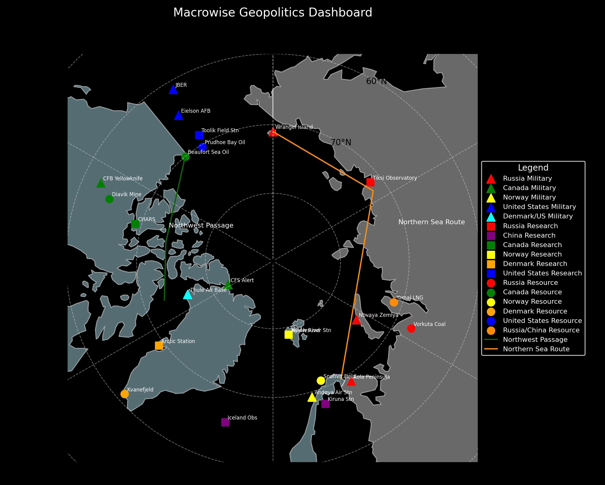
To make sense of this competition, we’ve built a map part of the "Macrowise Geopolitics Dashboard." It’s a polar view of the Arctic, showing who’s where and what they’re doing. Russia’s military bases are red triangles, China’s research stations are purple squares, U.S. assets are blue—triangles for military, squares for research, circles for resources. Canada’s in green, Norway’s in yellow, Denmark’s in orange. The NSR is a dark orange line, showing China-Russia teamwork, while the Northwest Passage is dark green, reflecting the U.S.-Canada dispute. NATO countries are shaded light blue, the U.S. a slightly brighter sky blue, and Russia in gray. The legend sits off to the right, keeping things clean and easy to read.
The U.S. Strategy: Greenland, Canada, and Leverage
The U.S. has a clear goal: secure its spot in the Arctic. Back in 2019, the Trump administration floated the idea of buying Greenland from Denmark. It sounded outlandish, but the reasoning was solid—Thule Air Base is key for missile defense, and Kvanefjeld’s rare earths are a big deal for tech, per Foreign Affairs. Fast forward to March 2025, and the U.S. is playing a different card: trade pressure on Canada. On March 4, 2025, tariffs of 25% on Canadian goods and 10% on energy and minerals were announced, tied to trade imbalances and security issues. They were paused after 30 days, but the message was clear. Canada claims the Northwest Passage as its own—40% of its land is in the Arctic—but the U.S. wants it open to all. Those tariffs are a nudge to get Canada on the same page, ensuring the U.S. can use the passage and keep its military and trade edge in the region.
Arctic Routes vs. Suez in 2050: A Numbers Game
Looking ahead to 2050, the Arctic could change how the world moves goods. The NSR and Northwest Passage, open 120 days a year in 2024, might stretch to 180 days as ice keeps melting, per NSIDC projections. The Suez Canal moved 1.2 billion tons of cargo in 2023—12% of global trade, per Suez Canal Authority—but it’s got limits. It can handle 80 ships a day, and a 2021 blockage cost $9.6 billion in delays, per Lloyd’s List. The NSR, on the other hand, saves 10-15 days and $500,000 in fuel per trip, with no $300,000 canal fee, per Nikkei. By 2050, the Arctic could handle 10% of global trade, up from 1% in 2023, per Arctic Council estimates. There are hurdles—ice risks and Russia’s control over the NSR—but the Suez has its own problems, like Red Sea attacks in 2023 and capacity constraints.
What It All Means
The Arctic Silk Road isn’t just about shipping—it’s about who gets to set the rules for the future. Russia, China, the U.S., and NATO allies are all in the game, each with their own assets and strategies. The "Macrowise Geopolitics Dashboard" lays it out clearly: red, purple, blue, green, yellow, and orange markers showing where the action is. The U.S. is playing smart, using its bases, Greenland’s value, and trade pressure on Canada to stay ahead. By 2050, the Arctic could be a bigger deal than the Suez Canal, but for now, it’s a slow, steady race—one where the stakes are as high as the rewards.
Thanks for reading,
Guillermo Valencia A
Cofounder of Macrowise
March 19th, 2025